
With the California wine industry generating nearly $100 billion in income, the protection and wellbeing of local vineyards is an important economic factor both locally and nationwide.
First reported in California in 1994, the glassy-winged sharpshooter (GWSS) was identified as an invasive species that causes widespread damages to grapevines. The insect was found to be spreading Xylella fastidiosa, a ruinous bacterium that causes Pierce’s disease which kills grapevines. Considering the economic ramifications of the disease’s effect, Solano County sought to address the problem at its root after finding a GWSS infestation in Vacaville near the prominent grape growing areas in Susuin and Napa valleys.
In order to track the widespread effects of GWSS, the Solano County Agriculture Department was utilizing spreadsheets to document insect locations and vegetation was being treated. Due to the large amount of data that was necessary to accomplish this, the files were starting to become overly complex and unmanageable. Additionally, the County recognized the need to track this data spatially. To remedy these challenges, KCI was approached to develop a tool that was capable of better tracking insect populations and more efficiently managing the emergency quarantine and eradication response.
The proposed tool needed to successfully track GWSS locations, facilitate property inspections, and document pesticide treatments. Additionally, the tool needed to provide end-users the ability to perform spatial analysis on GWSS finds, giving the user the ability to quickly and automatically tag properties within ¼ mile of insect finds. Additional requirements included both field and desktop workflows, the ability to store notes and images, track all activities against standardized address datasets, and the ability to report out the data collected using the solution.
 KCI solutions engineers were contracted to create an easily accessible database for tracking the invasive species.
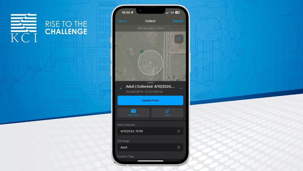
Working with the County’s Agricultural Commissioner, our team began to develop an interactive, map-based tool that would allow inspectors to log problem areas and tag properties for treatment in real time while in the field. The solution utilized Esri’s Field Map, which combines data collection, map viewing and location tracking capabilities into a singular tool, and Esri’s WebApp Builder, an online application configuration tool. To facilitate ease of access and accurate data analysis, KCI built a variety of visual formats into the front-end design that users and stakeholders could use to easily view specific records.
“To protect the state’s agricultural infrastructure, Solano County required a real-time solution that allowed users to view the most up-to-date data in the field and in the office. With the new solution in place, glassy-winged sharpshooters can be accurately tracked and treated on a more widespread scale.”
– David Thompson, Technology Project Manager
KCI implemented multiple datasets to create the interactive tool with layered maps offering field inspectors the ability to analyze, tag, and process land parcels based on their proximity to previously discovered GWSS populations. The app’s organization and user-friendly design modernized GWSS tracking efforts from the previous spreadsheet to now a map-based data collection solution.
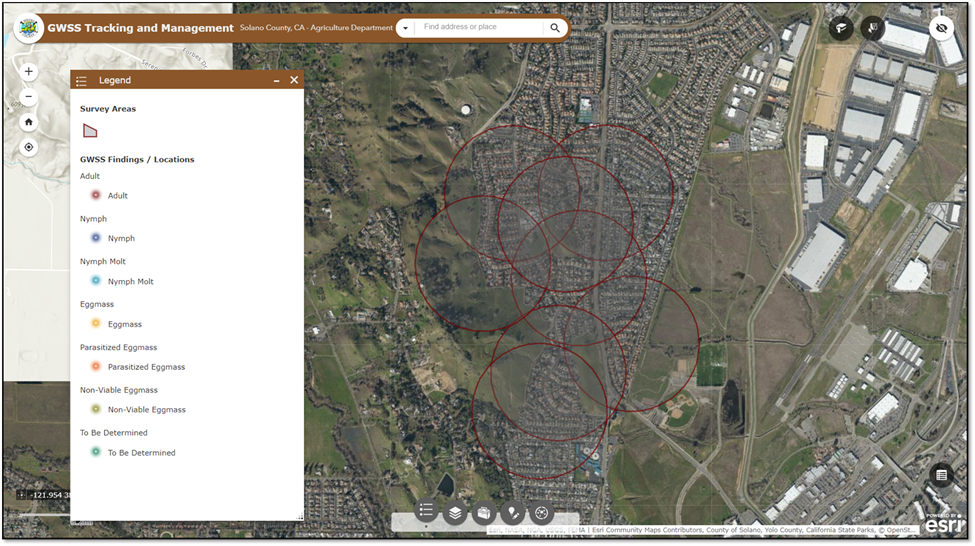 With options to view information about insect detections, pesticide treatment locations, and inspection results, the GIS tool offers a snapshot of data as soon as it’s available.
KCI’s configuration of the app enables County personnel to rapidly visualize data and make critical decisions regarding the management of the devastating insect. Local inspectors are now able to pinpoint precise insect locations, track lab results, and tag properties for inspection and treatment – allowing County agricultural staff to address concerns before they reach detrimental levels.
The newfound ability to collect data and document treatment activities as they occur shifts the way agricultural inspectors can react to potentially devastating insect species. Additionally, KCI’s GIS app plays a significant role in fostering transparency and encouraging public understanding of how the insects are being managed. Documentation and tracking efforts, which previously required repetitive and manual steps to complete, can now be seen immediately empowering County personnel to make important decisions efficiently and communicate accurate information with key stakeholders when it matters most.